The Myers Farm
Deed - May 4, 1818
to Michael Alkire and Moses Colvin
assignees of Joseph Kerr
assignee of David Scott
in consideration of his military service
as Captain in the Virginia Line
of the Continental Establishment
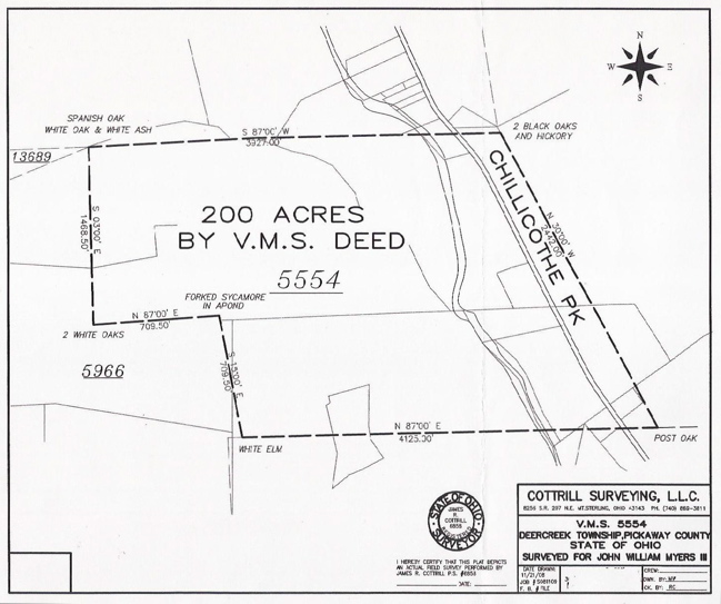
Survey - March 15, 1808
V.M.S. No. 5554, 200 Acres,
a part of Military Warrant No. 5100
Click image below for high-resolution version
Deed - Front
Deed - Back
Survey - Original

Survey - Virtual
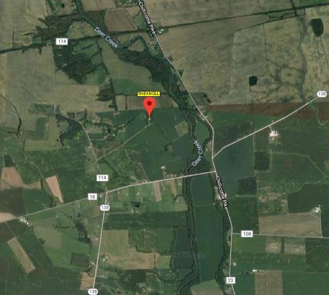
Satellite View Showing Location of The Farmhouse "The Knoll"
 Google Maps Link
The tract of land represented by this deed, later known as the Myers Farm, was purchased by William McCafferty in 1870 and occupied by his eldest child, Mary McCafferty, and her husband, John Jacob Myers, and their six-month-old son, John William Myers, who was born on January 23, 1870, and died November 4, 1936.
To view a map centered on the farm house click on the following link:
Myers Farm House Map
The map will open in a new window. Click "+" four times to get the closest possible view of the house.
The original deed was archivally framed so that it would not deteriorate further and then scanned. In the future, it may be restored and re-scanned.
The original survey was located by Randy Cottrill of Cottril Surveying in Mt. Sterling, Ohio, who also created the virtual survey from the description given in the deed.
It is possible that one of the assignees mentioned in the deed was the Michael Alkire who was married to Dorothy Phebus, who had a brother, George Phebus, a name mentioned in the original survey.
If you have additional information or corrections regarding this document, please contact me (see Contact Information at the top of this page).
Hand-written items are underscored; added notes are {italicized-bracketed}.
{CONVERSIONS FOR LAND MEASUREMENTS
Length: 1 chain = 100 links = 4 poles = 4 rods = 66 feet = 20.1168 meters
Area: 1 Acre = 10 square chains = 160 poles = 43,560 square feet = 0.4047 hectare}
Front
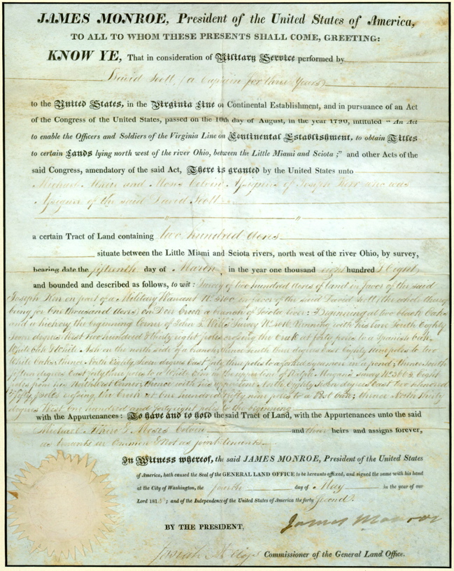
JAMES MONROE, President of the United States of America,
TO ALL WHOM THESE PRESENT SHALL COME, GREETING:
KNOW YE, That in consideration of Military Service performed by
David Scott, (a Captain for three years)
to the United States, in the Virginia Line on Continental Establishment, and in pursuance of an Act
of the Congress of the United States, passed on the 10th day of August, in the year 1790, intituled " An Act
to enable the Officers and Soldiers of the Virginia Line on Continental Establishment, to obtain Titles
to certain Lands lying north west of the river Ohio, between the Little Miami and Sciota ;" and other Acts of the
said Congress, amendatory of the said Act, There is granted by the United States unto
Michael Alkire and Moses Colvin Assignees of Joseph Kerr who was
Assignee of the said David Scott
a certain Tract of Land containing two hundred acres
situate between the Little Miami and Scioto rivers, north west of the Ohio, by survey,
bearing date the fifteenth day of March in the year one thousand eight hundred & eight
and bounded and described as follows, to wit: Survey of two hundred acres of land in favor of the said
Joseph Kerr on part of a Military Warrant No. 5100 in favor of the said David Scott (the whole thing
being for one thousand acres) on Deer Creek a branch of Sciota River: Beginning at two black Oaks
and a hickory, the beginning Corner of John S. Willis' Survey No. 4016, Running with his line South Eighty
Seven degrees West two hundred & thirty eight poles crossing the Creek at forty poles to a Spanish Oak,
White Oak & White Ash on the north side of a branch; thence South three degrees East Eighty nine poles to two
White Oaks; thence North Eighty Seven degrees East forty three poles to a forked Sycamore in a pond; thence South
fifteen degrees East forty three poles to a White Elm in the upper line of Ralph Morgan's survey No. 3665 Eight
poles from his North West Corner; thence with his upper line North Eighty Seven degrees East two hundred
& fifty poles crossing the Creek at one hundred & fifty nine poles to a Post Oak; thence North thirty
degrees West one hundred and forty eight poles to the beginning
with the Appurtenances: To have and to hold the said Tract of Land, with the Appurtenances unto the said
Michael Alkire & Moses Colvin and their heirs and assigns forever,
as tenants in Common & not as joint tenants.
In Witness whereof, the said JAMES MONROE, President of the United States
of America, hath caused the Seal of the GENERAL LAND OFFICE to be hereunto affixed, and signed the same with his hand
at the City of Washington, the fourth day of May in the year of our
Lord 1818; and of the Independence of the United States of America the forty second.
BY THE PRESIDENT, James Monroe
Josiah Meige Commissioner of the General Land Office
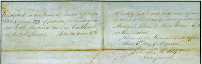
Back
Recorded in the General Land Office in Vol. 8 page 279 of patents for Lands granted to the Virginia Line on Continental Establishment. John M. Moore Clk?
I Certify that David Scott was originally entitled to the Bounty Land granted unto Michael Alkire & Moses Colvin by the? within Patent.
Given at the General Land Office
this 4th day of May 1818
Josiah Meigs
Commissioner
Hand-written items are underscored; added notes are {italicized-bracketed}.
{CONVERSIONS FOR LAND MEASUREMENTS
Length: 1 chain = 100 links = 4 poles = 4 rods = 66 feet = 20.1168 meters
Area: 1 Acre = 10 square chains = 160 poles = 43,560 square feet = 0.4047 hectare}
No. 5554 200-Acres 505B
Surveyed for Joseph Kerr, {illegible} 200 Acres of land on part of a Military Warrant No. 5100, on Deer Creek a branch of Siota Rive. Beginning at two Black Oaks and a Hickory the beginning corner of John S. Willis Survey No. 4016. running with his line S87W 238 poles crossing the creek at 40 poles to a Spanish Oak, White Oak and White Ash on the North Side of a branch, thence S3E 89 poles to two White Oaks, thence N87E 43 poles to a forked Sycamore in a pond, thence S15E 43 poles to a White Elm in the upper line of Ralph Morgan's Survey No. 3665, eight poles from his Northwest corner, thence with his upper line N87E 250 poles crossing the creek at 159 poles to a Post Oak, thence N30W 148 poles to the beginning.
Joseph Kerr L.{?} S. March 15th, 1808
John McClean, George Phebus - c.c. Elias Langham - April 15th, 1808
This information is provided for the use of persons engaged in non-commercial genealogical research
and any commercial use whatsoever is strictly prohibited. Copyright © 2005 by John William Myers III.
|
|


 Google Maps Link