Tract 6,
Lands Willed by William McCafferty
Pickaway County, Ohio
Click image below for high-resolution version
Document
The original document was archivally framed so that it would not deteriorate further and then scanned.
If you have additional information or corrections regarding this document, please contact me (see Contact Information at the top of this page).
Entire document is hand-written; added notes are {italicized-bracketed}.
{CONVERSIONS FOR LAND MEASUREMENTS
Length: 1 chain = 100 links = 4 poles = 4 rods = 66 feet = 20.1168 meters
Area: 1 Acre = 10 square chains = 160 poles = 43,560 square feet = 0.4047 hectare}
Front
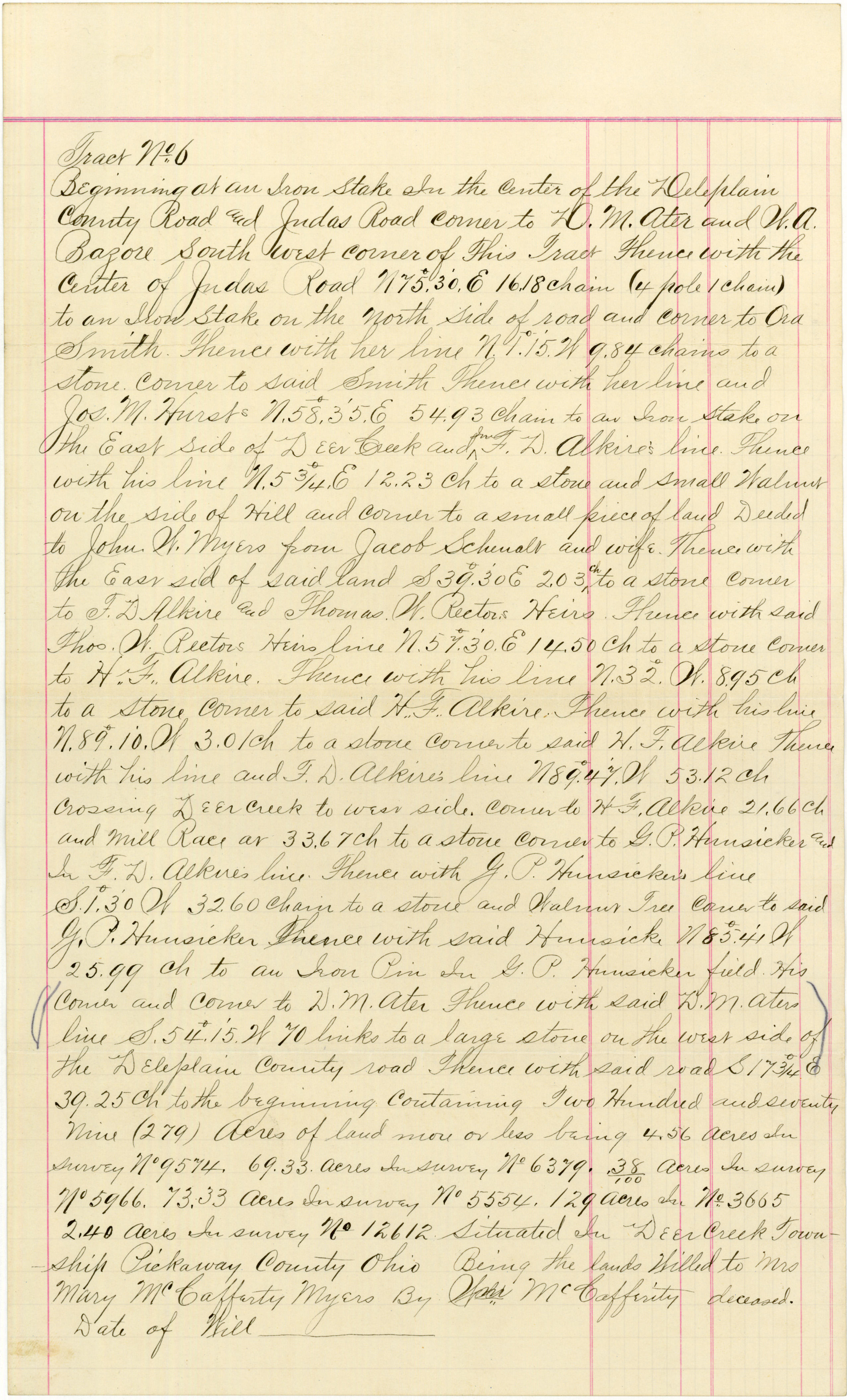
Tract No. 6
Beginning at an Iron Stake In the center of the Deleplain County Road and Judas Road corner to D. M. Ater and W. A. Bazore South West corner of This Tract{.} Thence with the Center of Judas Road N 75°, 30', E 16.18 chain (4 pole 1 chain) to an Iron Stake on the North Side of road and corner to Ora Smith. Thence with her line N 1°, 15', W 9.84 chains to a stone corner to said Smith Thence with her line and Jos. M. Hurst's N. 58°, 35', E 54.93 chain to an Iron Stake on the East side of Deer Creek and In F. D. Alkire's line. Thence with his line N. 5¾° E 12.23 ch to a stone and small Walnut on the side of Hill and corner to a small piece of land Deeded to John W. Myers from Jacob Schenalt and wife. Thence with the East sid{e} of said land S 39°, 30' E 2.03 ch to a stone corner to F. D. Alkire and Thomas W. Rector's Heirs. Thence with said Thos. W. Rector's Heirs line N. 57°, 30', E 14.50 ch to a stone corner to H. F. Alkire. Thence with his line N. 32° W 8.95 ch to a stone corner to said H. F. Alkire. Thence with his line N. 89°, 10', W 3.0 ch to a stone corner to said H. F. Alkire{.} Thence with his line and F. D. Alkire's line N 89°, 47', W 53.12 ch crossing Deer Creek to West side corner to H. F. Alkire 21.66 ch and Mill Race at 33.67 ch to a stone corner to G. P. Hunsicker and In F. D. Alkire's line. Thence with G. P. Hunsicker's line S. 1°, 30' W 32.60 chain to a stone and Walnut Tree corner to said G. P. Hunsicker{.} Thence with said Hunsicke{r} N 85°, 41' W 25.99 ch to an Iron Pin In G. P. Hunsicker field. His Corner and Corner to D. M. Ater{.} Thence with said D. M. Ater's line S. 54°, 15', W 70 links to a large stone on the West side of the Deleplain County road{.} Thence with said road S 17¾° E 39.25 ch to the beginning Containing Two Hundred and seventy nine (279) Acres of land more or less being 4.56 Acres In Survey No. 9574, 69.33 Acres In Survey No. 6379, .38/100 {probably 0.38 or 38/100} Acres In Survey No. 5966, 73.33 Acres In Survey No. 5554, 129 Acres In No. 3665{,} 2.40 Acres In Survey No. 12612 Situated in Deer Creek Township{,} Pickaway County{,} Ohio{,} Being the lands Willed to Mrs Mary McCafferty Myers By Wm McCafferty deceased. Date of Will ________________
This information is provided for the use of persons engaged in non-commercial genealogical research
and any commercial use whatsoever is strictly prohibited. Copyright © 2005 by John William Myers III.
|
|